“FAMILY-FRIENDLY COMMUNITY MEETING ABOUT THE FORTAG PROJECT ON JUNE 18, 2025

MONTEREY COUNTY – The Transportation Agency for Monterey County (TAMC) and the City of Marina invites you to join them at a community meeting about the California Avenue segment of the Fort Ord Regional Trail and Greenway (FORTAG).
This family-friendly drop-in event will be on Wednesday, June 18, 2025, from 4-6 p.m. at the Marina Equestrian Center, located at 2830 5th Avenue, Marina. It will feature information booths, dinner and other light refreshments, an activity station for kids, and the opportunity for children to interact with horses and goats.
Todd Muck, TAMC’s Executive Director, said, "The meeting is an opportunity for community members to hear about this Measure X funded trail project that will connect us to outdoor spaces in a location that is fun for adults and children.”
Bruce Delgado, Mayor, City of Marina, added, “The California Avenue segment of the FORTAG trail is another game-changer for the City of Marina. It’s adding to the transformation of our city by connecting neighborhoods to one another while offering safer routes to schools and the former Fort Ord.”
The California segment of the FORTAG is part of a future 28-mile-long regional network connecting pedestrians, bicyclists, and people with disabilities to recreation, exercise, active transportation, safer routes to schools, the community, and the outdoors.
RSVP for the event and learn more at: https://www.tamcmonterey.org/fort-ord-regional-trail-greenway-california-avenue .
Comment and questions can be sent to: fortagcaliforniaave@publicinput.com
Background Information
FORTAG is proposed as a new paved regional active transportation route providing pedestrians, bicyclists, and people with disabilities with a safer corridor connecting Seaside, Marina, Del Rey Oaks, Monterey, and unincorporated communities. It will provide new routes for both residents and visitors to California State University Monterey Bay, the Fort Ord National Monument, and the Monterey Bay Sanctuary Scenic Trail. The project was identified in the Transportation Safety & Investment Plan approved by Monterey County voters as Measure X in 2016.
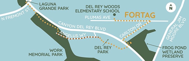
The Canyon Del Rey segment is the first phase of the Fort Ord Regional Trail and Greenway (FORTAG) to be constructed. This segment of the trail stretches 1.5 miles along the State Route 218 / Canyon Del Rey corridor through Del Rey Oaks and Seaside. Construction began in June 2024 and is estimated to be completed in 2026.
Canyon Del Rey Segment Project Map:
The California Avenue Segment will connect to the Jerry Smith Trailhead Segment, which is also currently in design. The Jerry Smith Trailhead segment stretches 2.25 miles from Imjin Road to the Jerry Smith Trailhead with access to the Fort Ord National Monument. This segment was awarded $7.148M in funding from the Federal Lands Access Program. Final design is currently underway, and the project is scheduled to begin construction in 2027.
The California Avenue and Jerry Smith Trailhead Segment Project Map:

###
The Transportation Agency for Monterey County (TAMC) is responsible for investing in regional transportation projects for Monterey County residents, businesses, and visitors. The mission of TAMC is to develop and maintain a multimodal transportation system that enhances mobility, safety, access, environment quality and economic activities in Monterey County. We are committed to helping our communities to thrive and grow! For more information visit www.tamcmonterey.org or call 831.775.0903.